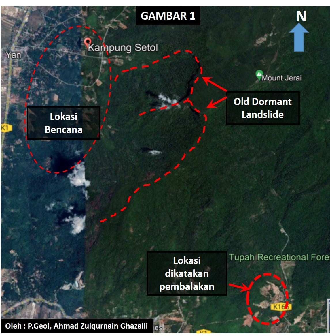
Old-dormant landslide is an inactive landslide that can be reactivated by its original causes or other causes that will trigger its mechanism. It is normally overshadowed by thick and densely forested, wet tropical hilly terrain and highlands. The older the landslide, the more difficult for it to be recognized although the causes of movement remain apparent.
Due to these reasons, local geoscientists tend to ignore this type of landslide. Dormant landslide can be classified as a serious natural terrain geohazard and can cause very costly consequences. This is because it can re-collapse or still in the process of collapse without any significant trace. Besides human interventions such as deforestation and mining, it also can be triggered by extreme natural events such as earthquakes and heavy rainfall. These things will affect the structure and mechanical stability and make the soil vulnerable to oversaturation and erosion (Salleh et al., 2019).
Old-dormant landslides are usually mollified by exogenic processes such as weathering, erosion, and massive or rapid deposition. Due to its occurrence in the past, it consists of loose soils or rocks which are easily saturated with water and newly covered with plants. The rate of recolonization by vegetation depends on the local climate and local vegetation. This could be the danger of dormant landslide. However, the size of each dormant landslide can go up to hundreds to thousands of meters in width and length which also contribute to the reasons on why people tend to overlook dormant landslide.
The main signature figures that need to be inspect attentively are arcuate crown, main head scarp, side scarps, concave upper slope, convex lower slope followed by undulating hummocky topography. There is also the presence of colluvial deposit at the foot of the slope or in the downstream valley floor, Y-shaped bifurcating streamlets in the upstream, the existence of stepped terraces, and contrast in vegetation cover compared to the slope counterparts. Besides identifying the structure, these features can also help estimate the relative age of old-dormant landslides (Jamaluddin, 2019).
Other than that, it also contains filigree, curved edge, lateral slope, concave slope at the top and convex topography at the bottom, the diversion of the river flow system, and differences in plant density. Some of the examples of this case in Malaysia are Cameron Highland, Pahang and a few areas in such as Kundasang, Ranau, Sabah. Due to its hazards and extensive damage, this type of landslide needs to be avoided.
With advanced technologies in terrain imaging and remote sensing such as LiDAR, IFSAR, INSAR, Google Earth, and airborne laser scanning (ALS), this geo-disaster can be identified earlier and avoided. LiDAR-derived conditioning factors were more sufficient in generating an accurate landslide susceptibility map (Jebur, Pradhan, & Tehrany, 2014). For airborne LiDAR and aerial photos, regional earthflow activity and sediment flux can be documented (Roering et al., 2015). After getting the images from the mentioned technologies, the landslide’s characteristics, susceptibility, hazard, and risk need to be identified and analysed (Razak et al., 2011), (Jebur, Pradhan, & Tehrany, 2014).
The internal structure of landslides next can be determined using geophysical tools such as seismic, geo-electrical imaging, and electromagnetic methods. These tools allow the establishment of material inhomogeneities, boundaries, and properties of materials (Van et al., 2007). The mentioned geophysical tools that can be used to determine the internal structure are also offered in Geoventure Solution Sdn Bhd such as Multichannel Analysis of Surface Waves (MASW), resistivity survey and seismic refraction survey.
These data will aid in the classification of the hazard degree for the landslide. The danger zone in the dormant landslide can be determined through classification according to the degree of gradient in addition to the type or geology of the base rock. Besides that, a detailed observation on the morphology and hill slope topography are needed for this type of geo-disaster.
When the dormant landslide has been detected, the affected area needs to be avoided especially from doing any development activities. Thus, identifying the old dormant landslides and avoiding any development on them is the best option to overcome this problem. The identified dormant landslide needs to be defined in terms of characteristics, susceptibility, hazard, and risk (K.A Razak et al, 2011). Furthermore, any available inventory map from previous surveys may yield crucial insight into the area of dormant landslide, typology, geometrical characteristics, possible causal factors, and historic damage (Van Westen et al, 2008).
In conclusion, dormant landslide is an inactive landslide that can be reactivated by certain causes and can be a damage to its surrounding. Although it is just a dormant landslide, it still can cause fatal injuries to human. Nowadays, dormant landslides are being taken lightly (ignored) due to its appearance that is not easily recognized. The only way to overcome this landslide is by avoiding the place declared as a dormant landslide. By using advanced technologies and data processing, geologists can identify whether the area is a dormant landslide or not. It is better to prevent or avoid than curing. Recently, there are still lack of convenient ways to overcome the dormant landslide.
LIST OF REFERENCES
- Mohd Salleh, M. R., Ismail, Z., Mohd Ariff, S. A., Abd Rahman, M. Z., Abdul Khanan, M. F., Asmadi, M. A., & Razak, K. A. (2019). Spatial Prediction Models for Landslide Activity Mapping Using Vegetation Anomalies. International Archives of the Photogrammetry, Remote Sensing & Spatial Information Sciences.
- Gupta, R., & Joshi, B. (1990). Landslide Hazard Zoning Using The GIS Approach – A Case Study from The Ramganga Catchment, Himalayas. Engineering Geology, 28(1-2), 119-131. doi: 10.1016/0013-7952(90)90037-2.
- Razak, K., Straatsma, M., van Westen, C., Malet, J., & de Jong, S. (2011). Airborne Laser Scanning of Forested Landslides Characterization: Terrain Model Quality and Visualization. Geomorphology, 126 (1-2), 186-200. doi: 10.1016/j.geomorph.2010.11.003.
- Roering, J., Mackey, B., Handwerger, A., Booth, A., Schmidt, D., Bennett, G., & Cerovski-Darriau, C. (2015). Beyond The Angle of Repose: A Review and Synthesis of Landslide Processes in Response to Rapid Uplift, Eel River, Northern California. Geomorphology, 236, 109-131. doi: 10.1016/j.geomorph.2015.02.013.
- Jebur, M. N., Pradhan, B., & Tehrany, M. S. (2014). Optimization of Landslide Conditioning Factors Using Very High-Resolution Airborne Laser Scanning (LiDAR) data at catchment scale. Remote Sensing of Environment, 152, 150-165.
- Jamaluddin, T. A., Sulaiman, N., & Nazer, N. S. M. (2020). Penilaian Geomorfologi Tanah Runtuh Lama di Tanah Tinggi Tropika-Kajian Kes Cameron Highlands dan Kundasang, Malaysia. Bulletin of the Geological Society of Malaysia, 69.
- Van Den Eeckhaut, M., Verstraeten, G., & Poesen, J. (2007). Morphology and Internal Structure of a Dormant Landslide In a Hilly Area: The Collinabos Landslide (Belgium). Geomorphology, 89(3-4), 258-273.
Geoventure Solution Sdn Bhd | Geophysical & Geological Services. (2021). Retrieved 19 May 2021, from https://www.geoventuresolution.com.my/.